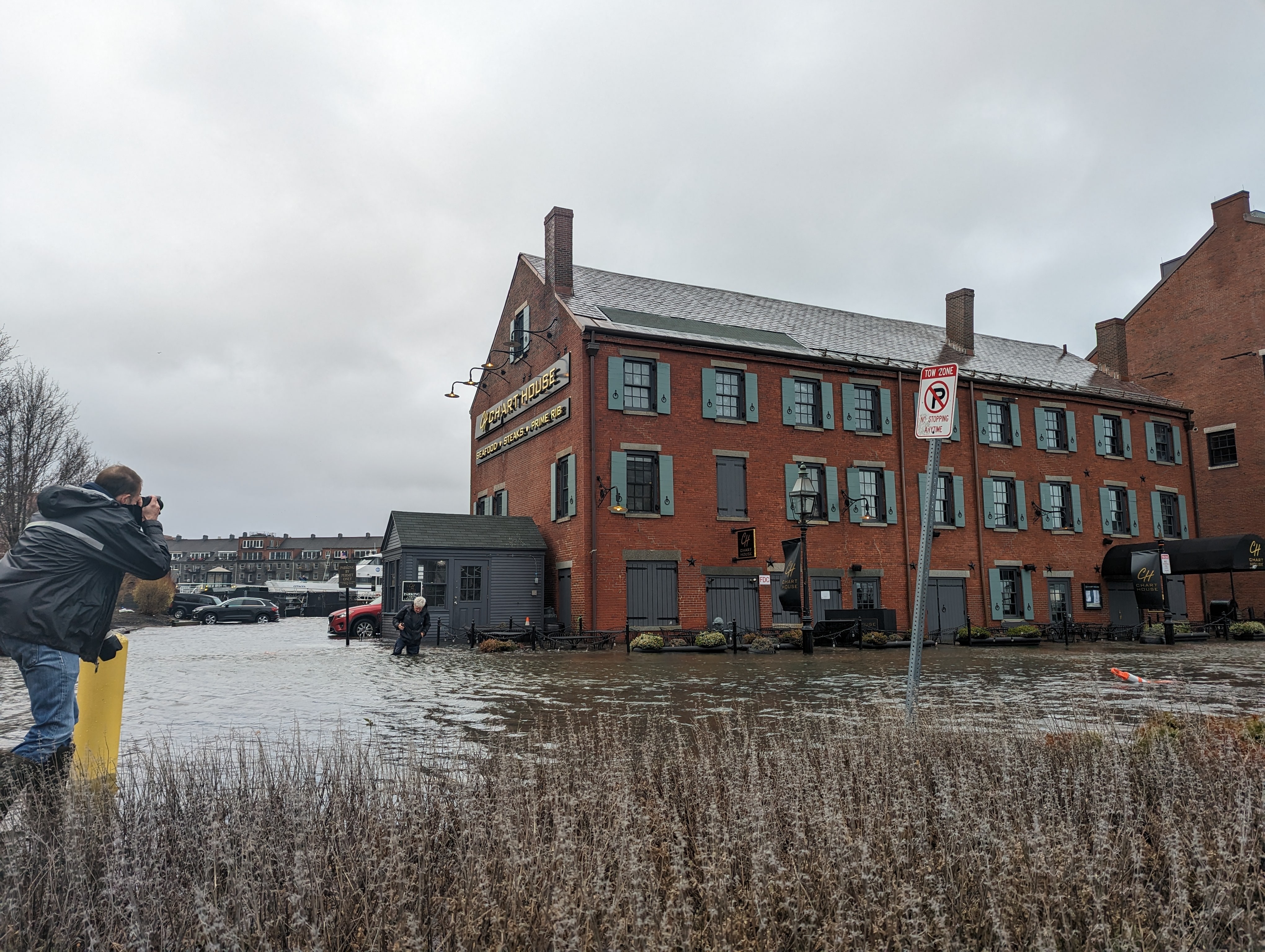
A photojournalist takes a picture of a person wading in storm-driven flood waters on Long Wharf on Dec. 23, 2022. An $800,000 engineering study will guide Boston’s plans to build flood barriers at the wharf and protect properties such as the Chart House. Photo by James Sanna | Banker & Tradesman Staff
Once mainstays of its shipbuilding and maritime import economy, Boston Harbor’s piers are figuring prominently in attempts to protect 21st-century neighborhoods and waterfront real estate from sea level rise.
Recent proposals and studies on piers in Charlestown, downtown and East Boston illustrate the engineering and financial challenges that still need to be overcome.
“Long Wharf presents a challenge to the city: how do you maintain access to the tourist attractions and the transportation elements, but also keep it from going under water?” said Nick Black, managing director of the Boston waterfront initiative for The Trustees of Reservations.
The Boston Planning & Development Agency is set to award an $800,000 engineering study for Long Wharf resiliency projects. The agency rejected three proposals for housing developments at its Pier 5 in Charlestown in 2021, citing safety and financing concerns. And in East Boston, The Trustees of Reservations are nearing final designs that would welcome harbor waters onto a long-abandoned pier in the form of marsh and tidal pool areas.
High Stakes at High Tide for Developers
The stakes are high for owners of properties such as the Marriott Boston Long Wharf Hotel and Custom House Block.
By the 2030s, the 1 percent annual floodplain will cross the Greenway and reach Boston City Hall, a Climate Ready Boston study predicted. And by the 2050s, without construction of a flood defense, Atlantic Avenue will have to be closed to traffic on a monthly basis during high tides.
An earlier city study estimated the cost of Long Wharf flood mitigation construction at up to $46.4 million. Options included a two-tier flood protection strategy that elevates the waterfront and builds a second line of defense inland.
“We’re looking to dig in and get an understanding of the structural limitations and characteristics in the area,” said Chris Busch, the BPDA’s assistant deputy director for climate and environmental planning. “There are a couple of locations where we could have flood protection along the shoreline, but need to evaluate that with the consultants.”
Selection of a final design will be complicated by factors such as maintaining access to commuter ferries and harbor cruises, noted Alice Brown, chief of policy and planning at Boston Harbor Now. And the MBTA Blue Line tunnel runs beneath the harbor floor under the pier, complicating the placement of new structures.
Built to store imports from 19th-century maritime trade, the 5-story Custom House now contains brick-and-beam tech office space overlooking Long Wharf’s commuter ferries and harbor cruise dock. New York-based developer Capital Properties bought the Custom House and neighboring Chart House in 2015 for $34 million.
The Custom House’s basement has flooded at high tide since the 1940s, according to a 2015 application submitted to the U.S. Environmental Protection Agency for a dewatering permit. Capital Properties did not respond to requests for comment.
Push for a Public Park at Pier 5
In 2021, the BPDA rejected three developers’ proposals for the long-abandoned Pier 5 in Charlestown, including two that included multifamily housing. The agency cited “serious” safety concerns due to projected rising sea levels. Nearby residents had also objected to the idea of development on the pier.
Since then, a group of local residents, The Pier 5 Association, has renewed a push to renovate the 2-acre pier as a public park. The BPDA has said it would support the project if it’s privately funded.
The Pier 5 Association commissioned a November 2021 study by DeSimone Consulting Engineers. Despite the pier’s deterioration since the Charlestown Navy Yard closed in 1975, it could be used as a public park after installation of a new concrete deck or new elevated walkway that rests on existing pile caps, the report concluded. The report did not include cost estimates.
“The cornerstone of our entire argument is that it should be a park, not privatized,” said Zachary Cutler, the group’s co-founder.

Steve Adams
So far, Cutler said, the group has focused on engineering considerations, rather than specific future uses, to determine its vision for the pier.
But the combination of climate change and deferred maintenance points to a future that acknowledges the harbor’s rising profile. Tidal ponds could be incorporated into sections of the deck, Cutler said, and used for environmental education programs.
And in East Boston, The Trustees of Reservations is finalizing designs by Michael Van Valkenburg Assoc. for the third phase of Massport’s Piers Park project that anticipate the projected 40-inch rise in Boston Harbor sea levels by 2070.
Features would include a salt marsh, coastal meadow and tide pool, according to preliminary designs released in November.
The designs have a nearby precedent in developer Lend Lease’s Clippership Wharf multifamily project, the city’s first to incorporate a vegetated living shoreline that absorbs flood waters and tidal flows.
The Trustees of Reservations has raised $32 million toward the Piers Park III project, which is estimated at up to $43 million, Black said. Following selection of a final design this year, the group hopes to begin construction in 2024.