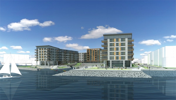
Developer Lend Lease elevated ground floors and will plant native species to create a “living shoreline” along the East Boston waterfront to mitigate potential future flooding at Clippership Wharf, a 477-unit condo and apartment complex expected to break ground by early 2016.
Nearly half of the 12 acres at the Clippership Wharf development parcel in East Boston are under water.
Developer Lend Lease wants to make sure the rest remain as dry as possible.
It’s pursuing an aggressive climate resiliency strategy as it designs 477 condos and apartments in four buildings within a stone’s throw of Boston Harbor.
Lend Lease sacrificed rentable space on the ground floor and moved its floor plates 3 feet higher than Federal Emergency Management Agency flood maps recommend. It’s planning to install flood-proof doors and gates to protect ground-floor common areas and retail spaces from storm surges. On the waterfront, it will fortify thousands of feet of seawall with riprap and plant a living shoreline covering 7,000 square feet to provide a buffer against surges.
“That’s the new normal relative to how these waterfront sites need to be designed,” said Nick Iselin, general manager of development for Lend Lease. “Sea levels will rise. We think it’s important to be a 100-year project rather than a 25-year project.”
The development’s design is also the exception, say developers and planners, despite a steady drumbeat of warnings about the potential damage that extreme weather could pose to some of the region’s priciest real estate in coming decades.
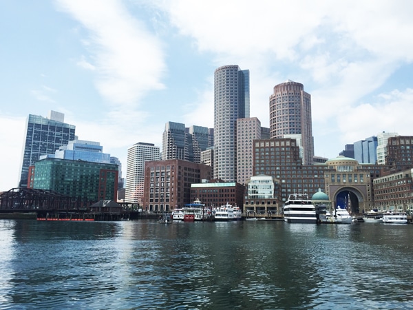
A study by Watertown-based Sasaki Assoc. identified $14 billion worth of commercial properties in Greater Boston that would be at risk during a major storm in 2050, when the mean sea level in Boston Harbor is projected to be 2 feet higher than today.
But there’s still little financial incentive to build structures designed to withstand the next few decades, planners and developers say.
“How do we say to a tenant, ‘It’s going to cost a little bit more in the short term, but in the long term the building is going to retain its value?” said Emily Keys Innes, an urban planner with The Cecil Group of Boston.
Climate change studies predict sea levels in Boston Harbor could rise more than two feet by 2050, but developers are just starting to incorporate flood-resilient designs.
Living With Water
The conflict between short-term profits and long-term sustainability is a key topic examined in “Developing Resilience,” the Urban Land Institute Boston/New England (ULI) chapter’s latest report on climate change.
The most popular public subsidies for infrastructure don’t pay for climate resiliency projects. Property insurance policies reflect short-term risks and are based upon FEMA maps using historical data, not the latest climate change studies. Current building codes and permitting processes don’t reflect future climate models.
At the same time, millions of square feet of office buildings and apartment towers have been built in the city’s bustling Seaport District since 2010 and more major developments are in permitting. Another construction boom is materializing in East Boston, where a half-dozen major multifamily developments are under construction or proposed.
Lend Lease, an Australian construction manager that is dipping its toe into the development game in Boston, New York and Chicago, sees an opportunity to build a model for waterfront sustainability at the long-vacant industrial pier at Jeffries Point.
It hired Boston-based landscape architects Halvorson Design, which worked with a coastal engineer and ecologist on plans to fortify the seawall, remove 2 acres of rotting pilings, and select native species to populate the living shoreline. The project will create 28,000 square feet of new coastal wetlands, including submerged land, coastal banks and tidal flats.
“The measures you take to be a resilient project can be rewarded by end users and investors buying your property. It depends on the approach to the market and the longevity of your project,” Iselin said.
Planes And Trains: Part Of The Solution?
The ULI study identified various public funding sources that could be modified to cover climate resiliency, from district improvement financing to the state’s “I-Cubed” infrastructure investment incentive program and Chapter 23L tax-exempt bonds.
One new source of funding suggested by the ULI study was a user fee placed upon the 31 million travelers who use Logan International Airport each year. Airport owner-operator Massport did not respond to a request for comment.
Expected major repairs to the beleaguered MBTA system could be designed to incorporate upgrades of low-lying transportation properties, Innes noted.
Finally, there’s the prescriptive approach. Chapter 91, the state law regulating waterfront development, could be used to compel climate-resilient designs. And flood-resistant infrastructure could be made part of the permitting process in cities such as Boston, Cambridge and Quincy
Boston last year began requiring developers to submit climate resiliency plans in permitting applications, although the designs are not required to be part of projects so far.
“If you’re prioritizing this in your project design, it’s a lot easier than if you’re looking at it at the very end,” said Brian Swett, director of cities and sustainable real estate for consulting engineers Arup Inc. and the city of Boston’s former environmental chief.
Quincy is partnering with Metropolitan Area Planning Council on a climate adaptation plan designed to protect properties, including major commercial centers like the former State Street South office park. Built in the 1970s on the banks of the Neponset River, the 60-acre park contains approximately 2 million square feet of office space.
Using a $75,000 grant from Coastal Zone Management, the city of Quincy has contracted with Woods Hole Group to extract local information from Boston Harbor sea level studies, Quincy Principal Planner Robert Stevens said. The draft climate action plan will be presented to the public next spring.
Developers’ best designs will be of little use without massive public investment, a discussion that is still in the early stages. Potential regional solutions suggested range from a Venice-like series of canals to a massive sea gate at the entrance to Boston Harbor, walling out flood waters.
“We’re trying to do this after a near-miss in Boston,” Swett said. “This stuff only works with a regional solution, but there isn’t a natural government body to oversee this.”