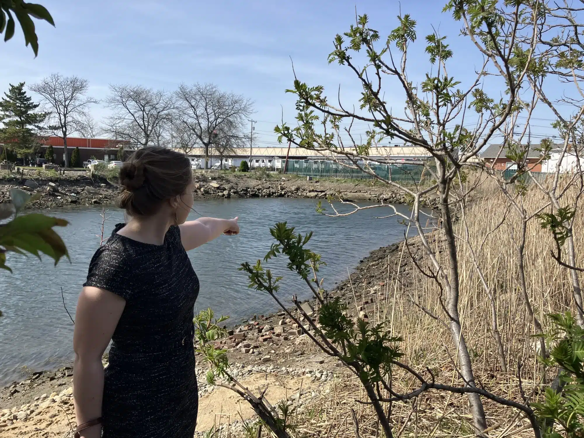
Emily Granoff, Chelsea’s deputy director of housing and community development, points at the culvert where the Island End River passes below the city. Photo by Jennifer Smith | CommonWealth Beacon
When the ax fellon $882 million in federal funding aimed at helping communities prepare for future flooding, it came paired with a critique of the program’s very purpose.
The Building Resilient Infrastructure and Communities (BRIC) program “was yet another example of a wasteful and ineffective FEMA program,” an unidentified FEMA spokesperson wrote in a press release on April 4. “It was more concerned with political agendas than helping Americans affected by natural disasters.”
Emily Granoff, Chelsea’s deputy director of housing community and development, was assisting another community with smaller scale grant work before the BRIC cuts were announced. Seeing the news, that community reached out to see if their funding was impacted, and Granoff assured them that it wasn’t.
But Chelsea and Everett had money on the line – a $120 million flood resilience project for the Island End River that included a storm surge barrier, storm surge control facility, and wetland restoration set to begin construction in 2026.
“And I looked up the press release,” Granoff said. “And then I cried for a bit.”
The local toll wouldn’t be felt fully for two weeks, when Massachusetts estimated that some $90 million in funding and potential grants would be pulled, almost $50 million of which was dedicated to the Chelsea and Everett endeavor. Overnight, project managers overseeing resilient park and stormwater flooding projects, updating drinking water and watershed regulations, and preparing for the best ways to hold rising waters at bay rushed to triage.
Granoff was among them, as the project manager for Chelsea in a partnership with Everett. Roughly between and beneath the ground of the two Gateway Cities – historically industrial midsized urban centers – passes the Island End River. This tributary to the Mystic River generates dramatic flooding during serious coastal storms, sending feet of water rushing over the nearby roadways, commercial, and industrial sites.
The risk of worsening storm surges is difficult to overstate, Granoff said as she walked the border of the proposed project site on an 80-degree April afternoon, bright sun bouncing off of gleaming high-tide waters and discarded glass and plastic bottles around the spot where the river dips into a massive culvert to pass beneath the city.
By 2081, the kind of 1-in-100-year storm surge events proportional to Hurricane Sandy could be annual occurrences, according to a 2022 study from the Woodwell Climate Research Center.
Within the 2070 flood risk zone sits Chelsea High School, a Market Basket, Route 1, Route 16, commuter rail and freight rail tracks, a Federal Bureau of Investigation building, and the New England Produce Center that distributes produce to 8 million people across the Northeast.
“Basically 10 years ago, the cities of Everett and Chelsea were evaluating their flood vulnerability and found that Island End River was a huge one – not just for us, but for those 8 million people and for anyone who drives into Boston from the North Shore,” Granoff said. “Because all those roads are gonna get flooded out in a coastal storm rain. It’s not really feasible to move Route 1 or Route 16. It’s not feasible to move the New England Produce Center. So we just gotta protect it.”
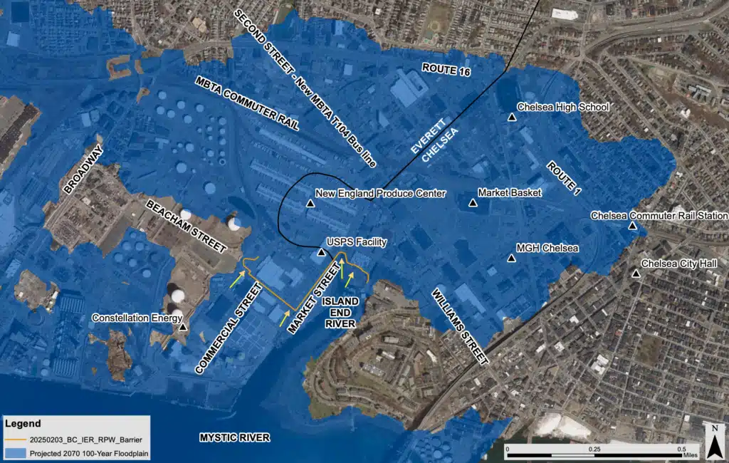
A view of expected flooding in Chelsea and Everett, with the proposed storm surge barrier outlined. Image courtesy of the city of Chelsea
When Chelsea and Everett were built out in the 18th and 19th centuries, wetlands became the site of a heavily industrial district full of critical infrastructure.
Defending that infrastructure, planners determined over the past decade, will require a barrier to prevent water from coming up out of the culvert beneath the island and out of the river around the island and spilling into its old riverbed and marshland path.
Part of the solution is a 3,000 square-foot, $42 million underground storm surge control facility would sink 8 to ten feet below ground and rise 6 to 8 feet above ground next to the small M&T bank building near the outlets of the Market and Beacham Street culverts. Because the river passes physically beneath the area through the culvert, an above-ground storm barrier that stops water from washing over the land wouldn’t stop the surge from blasting through the large culvert tunnel and flooding out through storm drains. So, the control facility would manage the flow of water under Chelsea and Everett while the barrier keeps most of the water from flowing over the cities.
Walking along the path of where the 4,460 linear-foot storm surge barrier – a wall occasionally broken up by gates to allow people and vehicles to pass though when the area isn’t flooding – would go involves weaving in and around city and private land. The path of the barrier has changed over the years, to accommodate issues like avoiding crossing rail tracks or making sure the water-dependent businesses along the port can access the water on which they depend.
On the Everett side, the barrier would wind around commercial sites to higher ground, ending roughly where 2070 estimates expect just a foot of flooding in intense storm events – annoying but manageable. On the Chelsea side, they plan to create a new high ground where the barrier can taper off behind a revamped riverwalk and restored salt marsh that are part of the 18,000 square feet of nature-based resilience improvements that include wetland upgrades.
The Island End River project was the largest chunk of the $90 million in Bay State BRIC cuts, but the impact sprawls from Eastern to Western Massachusetts.
“The Trump Administration has suddenly ripped the rug out from under cities and towns that had been promised funding to help them upgrade their roads, bridges, buildings and green spaces to mitigate risk and prevent disasters in the future,” Gov. Maura Healey said in April. “This makes our communities less safe and will increase costs for residents, municipalities and businesses.”
In dramatically re-orienting the US federal agency responsible for coordinating the country’s disaster relief efforts, the Trump administration cancelled all BRIC applications from Fiscal Years 2020-2023, imperiling states from New England to the Gulf Coast. Any undistributed funds would be immediately returned either to the Disaster Relief Fund or the US Treasury, according to FEMA.
Two major Boston resilience projects – Moakley Park in South Boston and Tenean Beach in Dorchester – are either having millions in funding pulled or grant applications cancelled. Funding for culvert projects in Acton, Brockton, Grafton, North Adams, and Taunton also got the axe.
More than two dozen Democratic congresspeople sent a letter to the acting FEMA administrator on April 23, urging the administration to reconsider the cuts.
“Ending the FEMA BRIC program is a terrible mistake and marks a huge setback for many climate-vulnerable cities and towns in my district,” wrote US Rep. Seth Moulton, who helmed the letter.
Newburyport mayor Sean Reardon noted that the town was expecting to receive a BRIC grant protect its watershed and drinking water supply, but “will now need to find other resources to do this important work.”
An irony, project proponents point out, is slicing away BRIC funding in the interests of shrinking the budget could cut the other way. Projects must go through a cost-benefit analysis to compare the upsides of a resilience project to what it would cost to build. If disaster washes up to a municipality’s doors because of flooding, FEMA gets the call and bears the cost.
At least, that’s how the system has worked for decades, but Trump in March signed an executive order directing state and local governments to “play a more active and significant role” in resilience and preparedness. The administration has since denied some federal funding to disaster-struck areas.
A project is considered cost-effective by FEMA when the ratio of future risk reduction benefits to its cost is 1 or greater. The Everett and Chelsea project’s ratio, which would include over $3.6 billion in protection of high-risk assets according to filings, is more than 38.
But without the FEMA funding, the math looks bleak.
Along with the $50 million BRIC funding, the cities expected to contribute $10 million in combined local funds. Planners have been working with the state to secure $45 million in funding and seeking the remaining $14.8 million through additional state and private foundation grants.
“We’ve had warning signs and storms where we’ve seen how disruptive it can be to have even a foot or two of flooding,” Granoff said, standing alongside a main drag that sees a thousand trucks a day roll through with produce and other goods, just a two minute walk from the culvert. “And that was one of the great things about this project, was that we were gonna prevent it from ever happening. We saw a risk, and we all agreed it was a risk, and we were gonna say we can fix this.”
They are looking at whether it would be possible to break the project into pieces, but Chelsea and Everett are communities with a higher proportion of low-income residents, without the budget for projects of this scale.
“Municipalities aren’t built to do this kind of huge infrastructure project,” Granoff said. “But even with all that, we were gonna do it. We’ll still have to do it.”
This article first appeared on CommonWealth Beacon and is republished here under a Creative Commons Attribution-NoDerivatives 4.0 International License.![]()