A flood barrier near Wharf 10 in the Raymond L. Flynn Marine Park was identified as a key early-stage element of an $850 million marine park resiliency plan. iStock photo
Boston officials hope to complete the first permanent resiliency projects by 2030 to protect coastal real estate from rising seas.
Designed to block major storm surge pathways into the Seaport District, the estimated $6.5 million project includes flood barriers on Wharf 8 near the Leader Bank Pavilion on Northern Avenue, and Pier 10 near the Boston Design Center on Drydock Avenue.
It would become the first phase of an estimated $850 million effort to insulate the 191-acre Raymond L. Flynn Marine Park and Seaport District from coastal flooding.
Home to a diverse economic cluster ranging from ship repair facilities to software companies and biotech researchers, the marine park’s 113 buildings are at risk of $1.3 billion in damages by 2070 from storms and a projected 40-inch rise in sea levels, according to a marine park flood mitigation report completed in March by a team of environmental and engineering consultants.
Boston Harbor Now, which manages the Boston Harborwalk, is studying how the new elevated flood barriers can be designed to preserve recent decades’ progress in expanding public access to the waterfront.
“It can be challenging, but it’s also possible,” said Joe Christo, chief resiliency officer for Boston Harbor Now. “You also have to be balancing those two priorities that are sometimes competing: preserving the water access while also making sure people are staying safe and the city is becoming more resilient.”
Neighborhood-Scale Protections Advance
Many individual property owners already have begun floodproofing their buildings, following coastal storms that inundated portions of the Seaport in recent years. Boston’s Office of Emergency Management has issued guidelines and permitting requirements for temporary deployable flood barriers on a citywide basis.

Early phases of the city’s flood-protection plans would be designed to plug major flooding routes in the Seaport, including one near the Leader Bank Pavilion, by 2030. Image by Arcadis | Courtesy of the city of Boston
But district-wide barriers will be necessary to protect coastal neighborhoods in coming decades, according to a series of studies submitted to city officials in the past decade.
The latest report, led by consultants Arcadis, details both short- and long-term resiliency strategies.
First steps would include construction of a new elevated seawall topped with the Boston Harborwalk on Northern Avenue behind the Leader Bank Pavilion by 2030. The area was identified in earlier Climate Ready Boston studies as a major flood path into the Seaport District.
A second early-stage project led by Massport would protect portions of Seaport Boulevard near the World Trade Center and Fish Pier. The report states both projects have hit the preliminary design stage and have been funded for construction.
The longer-term solution, a 6-foot-high flood barrier wrapping around the north and east side of the business park and Cruiseport Boston, has an estimated $820 million project cost and would begin after 2035, according to the report.
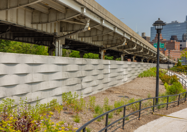
A flood wall in Stuyvesant Cove Park, New York provides an example of the potential design of resiliency projects in Boston’s Seaport District. Photo courtesy of the city of New York
Consultants cited a coastal resiliency project completed in 2023 in New York’s Stuyvesant Cove Park as an example of a potential design for the Boston storm barrier. The 1,400-foot-long project included a new floodwall and 16-ton swinging gate which remains open to allow public access to the waterfront, but shuts before storms and flooding. Other Manhattan waterfront parks have also been reengineered to mix flood defenses, plantings and public open space, with the latest opening last year.
Consultants also suggested pump stations will need to be installed to prevent stormwater from overwhelming drainage and sewer systems during coastal storms with significant precipitation.

Steve Adams
Split Between Developers and Public Sources
The Boston Planning & Development Agency has a financial stake in protecting the marine park’s commercial and industrial real estate: Its sister agency, the Economic Development & Industrial Corp. of Boston, owns most of the marine park and collects rents from developers through ground leases that help pay for the agency’s operations.
Under a policy created in 2021, marine park developers are asked to commit contributions toward the cost of future flood barrier projects. Developers including Marcus Partners, MP Boston and Cronin Group have agreed to payments, which would not be required until projects are finished.
All developers’ contributions are tied to the square-footage of their project as a percentage of the total marine park square-footage.
Other potential funding sources would include the BPDA general fund, city of Boston’s capital budget and state and federal grants, according to the report.