|
| 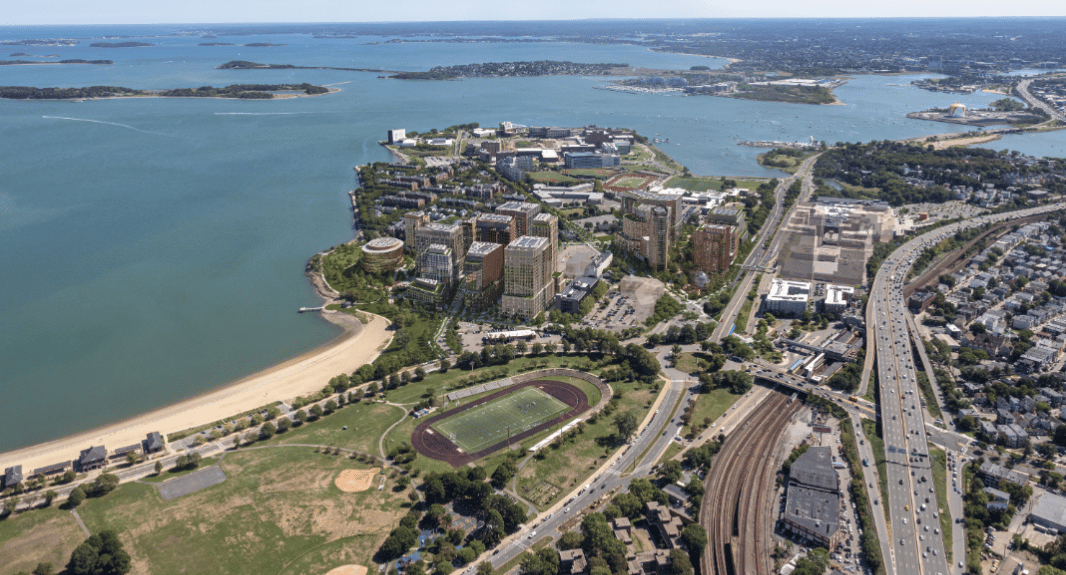
Image courtesy of Stantec Architecture D/R/E/A/M Collaborative
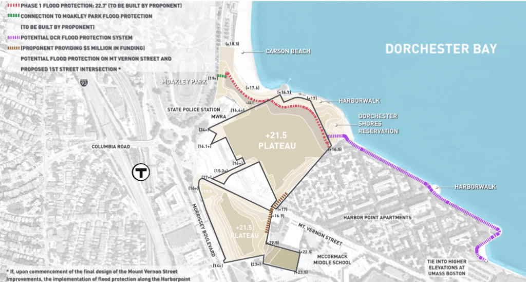
Dorchester Bay City developers will construct a nearly 23-foot-tall flood barrier designed to form a continuous coastal resiliency defense to South Boston’s Moakley Park, reflecting anticipating sea level rise.
Two planned buildings would be moved further inland to accommodate the barrier.
“This shift reflects the proponents’ commitment to helping to protect nearby areas and neighboring properties from rising sea levels in collaboration with Massachusetts Department of Conservation and Recreation (DCR) and the city of Boston, creating new open and green spaces for public enjoyment, and promoting sustainability measures early in the Project’s development timetable,” Accordia Partners and Ares Management wrote in a notification to the Boston Planning & Development Agency this week.
Reflecting comments from city and state agencies, the resiliency work would take place in the first phase of the 6.1 million-square-foot project. The site spans 36 acres including the former Bayside Expo Center property, an office park at 2 Morrissey Blvd. and the Boston Teachers Union headquarters at 180 Mt. Vernon St.
The city’s Climate Ready Dorchester study identified the site as a flood pathway during coastal storms. The revised proposal ties the project’s resiliency strategies into the neighboring state-owned Dorchester Shores Reservation and a planned city-sponsored project at South Boston’s Moakley Park, a site that Boston officials have identified as a key element of their coastal resiliency strategy.
The city’s coastal flood resilience design guidelines reflect an anticipated 40-inch rise in sea levels during major storms by 2070.
The 198,300-square-foot office-research building on block B and a 147-unit residential building on block C have been relocated 30 and 16 feet further from the waterfront to make room for the flood barrier.
Developers also are offering $5 million to the state Department of Conservation and Recreation to build a flood barrier on the Dorchester Shores Reservation next to the Harbor Point Apartments, a recommendation of the city’s Climate Ready Dorchester study.
The project now would include 9 acres of open space and pervious areas, up from the original 6.8 acres, including a 3.5-acre Dorchester Green park.
Income-restricted units would comprise 20 percent of the 1,957 housing units, up from the original 13 percent proposed in 2020. Developers also propose over 4 million square feet of office, R&D and academic uses and 180,900 square feet of ground floor retail and commercial space.
The project update reduces the size of the development on the Bayside Expo Center site by 350,000 square feet, including the replacement of a 112,000-square-foot residential building with a 6,300-square-foot pavilion next to the Dorchester Green park.
And an office-research building at block V1 at 2 Morrissey Boulevard would be replaced with a 243-unit residential building.
Developers and property owners are increasingly focusing on district-wide resiliency strategies as the most effective means of protecting coastal areas from sea level rise. In January, the Wharf District Council is expected to release a study recommending a unified flood defense system for a portion of the downtown Boston waterfront.