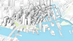
A rendering showing the area of downtown Boston that could be flooded by a so-called "100-year storm" by 2030 as sea levels rise and the severity of ordinary storms worsen. It's estimated that Boston has a 10 percent chance of being hit by a 100-year storms by 2033. Image courtesy of the Wharf District Council
Downtown Boston properties will be inundated by harbor waters with increasing frequency in coming decades, according to a study recommending an $877 million flood barrier protecting the central waterfront.
A consulting team led by Arup recommends elevating a 1.5-mile section of waterfront from Christopher Columbus Park to Congress Street, providing relief from sea levels expected to rise up to 51 inches by 2070 that would cause $3.9 billion in damages.
The report was commissioned by the Wharf District Council, a nonprofit neighborhood association that represents dozens of property owners including the New England Aquarium and Long Wharf Marriott hotel. The state legislature also earmarked $500,000 toward the report, which also received private contributions.
“It’s a really, really scary report to be honest,” said Marc Margulies, a Boston architect and president of the Wharf District Council. “Nobody wants to do this. Nobody wants to spend the money on it. But we have to do this.”
Approximately $250 million in projects are recommended by 2030 at Long Wharf, Central Wharf and Harbor Towers.
The report predicts threats to properties as far inland as Boston City Hall in coming decades during coastal storms. Even without storms, “sunny day” tidal flooding will begin to infiltrate the Central Artery Tunnel and MBTA Blue Line by the 2040s. By the 2060s, properties located across the Rose Fitzgerald Kennedy Greenway will be subject to sunny-day tidal flooding.
Along with threats to property values, flooding could impact key tourism destinations such as Faneuil Hall Marketplace and Long Wharf. Transportation is also at stake, with potential flooding to the Central Artery Tunnel and MBTA Blue and Orange lines, as well as commuter ferries and tourism cruises at Long Wharf.
Property owners submitted data to the consulting team in the past year, and have endorsed the report’s findings, Margulies said.
The Boston Harborwalk – which currently ranges from an elevation of 7 feet in front of the Harbor Towers condominiums to over 12 feet at Independence Wharf – will need to be elevated to approximately 19 feet across the district.
The report also recommends installation of living shorelines near the New England Aquarium that can absorb flood waters and buffer storm surges, similar to a design used at the Clippership Wharf development in East Boston.
“This latest report reinforces the need for comprehensive, collaborative planning along Boston’s waterfront. The New England Aquarium is proud to take an active role in this process as we work toward a resilient, accessible, and inclusive downtown waterfront for all,” CEO Vikki Spruill said in a statement.
And new drainage systems including underground cisterns will be needed to allow flooding on the inland side of the new barriers to escape, consultants said.

Maps show the potential depth of flooding in downtown Boston during so-called “100-year” storms in 2030, 2050 and 2070. Image courtesy of Arup
The Wharf District Council is seeking to have the report incorporated into the U.S. Army Corps of Engineers’ upcoming study of Boston flooding defenses. In February, the city entered a partnership with the Army Corps to develop a comprehensive coastal resiliency strategy, expected to take at least three years to complete.
“This is an extraordinary circumstance,” Margulies said. “Even though Boston has been moving eastward for 400 years, the ocean wants to move westward. And we have to deal with that.”
The city previously completed five resiliency studies for coastal neighborhoods as part of its Climate Ready Boston program.
In the most advanced project in the planning phase, a 2,090-foot-long sea wall would be built along the east side of Fort Point Channel between Necco Street and Dorchester Avenue. The city has applied for a FEMA grant to offset the cost of the $20 million project, and selected AECOM Technical Services Inc. to design the 6-foot-tall berm intended to protect 31 buildings from flooding.
The area includes the Gillette Co. campus and the new Eli Lilly Institute for Genetic Medicine currently under construction.
Editor’s note: This report has been updated with comment from New England Aquarium CEO Vikki Spruill.


