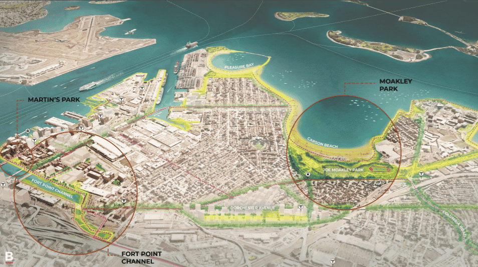
Protecting some of Boston’s most valuable and vulnerable coastal real estate in South Boston and the Seaport District will cost an estimated $1 billion, Mayor Marty Walsh said in laying out a citywide coastal resiliency plan.
The strategy calls for a series of new barriers and living shorelines that can absorb flood waters, along with plans to elevate major arteries prone to frequent flooding such as Morrissey Boulevard. The new barriers would protect areas being actively eyed for future development, such as Widett Circle and the former Bayside Expo property.
In South Boston, the initial projects would protect the 100-acres area near the future General Electric headquarters and a stretch of Seaport Boulevard near the World Trade Center that’s flooded in recent Nor’easters.
The city will seek to split the cost with state and federal sources, nearby private land owners and donors, Walsh said. Specific funding sources have not been identified, but Walsh said the city’s $230-million capital budget will increase by up to $20 million.
“People have been asking, ‘What’s Boston’s plan? What’s Boston’s plan?’ This pulls it all together under one roof,” Walsh said Tuesday.
The opportunity for shore-based protection measures comes after a UMass-Boston study this year rejected the idea of building a nearly $12-billion, 3.8-mile barrier across the mouth of Boston Harbor as too expensive and ineffective.
The South Boston coastal resilience plan released Tuesday recommends a series of district-wide defenses, in contrast to a piecemeal approach by individual property owners. Based upon projections of sea levels rising by 40 inches by 2070, severe storms could cause over $8 billion in damage to properties in Boston, the report said.
Winter storms in recent years have sent floodwaters down streets of Fort Point and the Long Wharf area, inundating the MBTA’s Aquarium station and threatening to spill down highway ramps into the Central Artery Tunnel system.
The South Boston plan — developed by the city’s Green Ribbon Commission with support from the Barr Foundation —reflects the threat that Fort Point Channel poses to nearby properties including the future General Electric headquarters and a 6-acre parking lot that Gillette Co. is marketing to developers.
The report says a berm on the Fort Point waterfront and a vegetated park could block and absorb much of the stormwater at an estimated cost of up to $12 million, part of an estimated $139 million in resiliency measures for the former industrial neighborhood which has become a high-tech cluster. Other projects would include a flood barrier along Seaport Boulevard between the World Trade Center and Dry Dock #4, and elevation of the Boston Harborwalk.