|
| 
A 3.8-mile-long gated barrier protecting Boston Harbor from storm surges would cost up to $11.8 billion and prove less effective than shore-based resiliency strategies, according to a study by the Sustainable Solutions Lab at University of Massachusetts-Boston.
The report funded by the Barr Foundation was released today as Boston Harbor Now sponsors a symposium on issues facing the waterfront, the city’s fastest-growing and most vulnerable development area. In place of a permanent sea barrier, the report recommends shore-based resiliency measures at an estimated cost of $1 billion to $2 billion.
“It doesn’t make sense for the city to consider any kind of harborwide barrier system,” said Paul Kirshen, a researcher at University of Massachusetts’ School for the Environment. “We feel so strongly that shore-based solutions for the next couple of decades are prudent.”
A resiliency plan for the Seaport District scheduled for release this summer will recommend a mix of new open spaces that absorb floodwaters, and walls that seal off flood channels between buildings, said Bud Ris, co-chair of the Boston Green Ribbon Commission’s climate preparedness working group. Similar plans have been floated for vulnerable sections of East Boston and Charlestown.
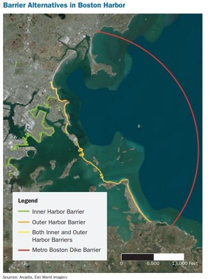
Researchers studied both a 3.8-mile outer harbor barrier from Winthrop to Hull, which would be the world’s largest such system, as well as an inner-harbor barrier from Logan International Airport to the Seaport District. They concluded the systems would pose a hazard to some vessels and wildlife and require increasingly frequent use if sea level rise projections come to pass, shortening the lifespan of the equipment.
The outer harbor barrier would require a pair of 1,500- and 650-foot-wide floating gates that increase velocity of currents and make navigation more difficult for smaller vessels, the study said. The inner harbor barrier would only require one gate with minimal effect on tides and currents and cost approximately $8.7 billion.
A deep water dike barrier from Cohasset to Swampscott was dismissed because of environmental effects and potential costs up to $85 billion.
The shoreline resiliency strategy includes some methods already being used by private developers at vulnerable waterfront properties.
Boston Properties installed temporary storm barriers outside its Atlantic Wharf office tower during this winter’s storms. Developer Lendlease is incorporating a permeable “living shoreline” at its 478-unit Clippership Wharf multifamily complex on the East Boston waterfront.
HYM Investment Group said it will elevate buildable sections of its Suffolk Downs property two to four feet to place buildings and roads above flood plains, as it seeks approval for a 16.5-million-square-foot development in East Boston and Revere.
The 2016 Climate Ready Boston study predicted local sea level increases of up to 1.2 feet by 2050 and 7.3 feet by 2100. The new study based its assumptions on increases of 1 foot by 2030, three feet by 2070 and five feet by 2100.
The report’s release comes just months after portions of the Seaport District and Rowes Wharf were inundated by flood waters during a Jan. 4 coastal storm, serving as a “wake-up call” for the real estate and business community, Kirshen said.