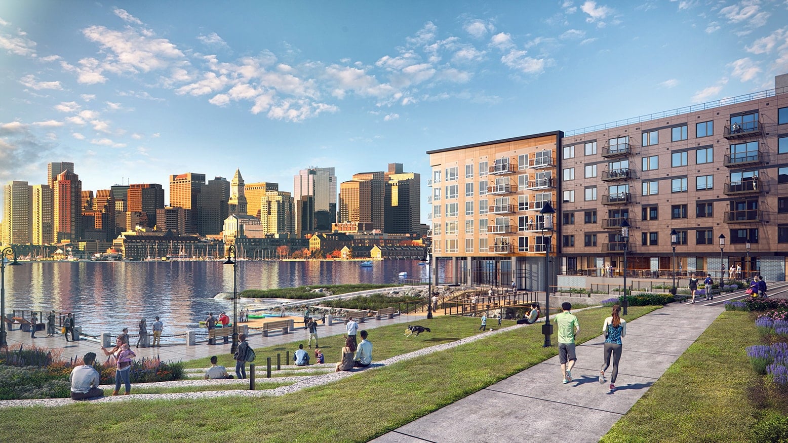
LendLease used a series of landscape architecture elements and 14 feet of fill to protect its new luxury residential project Clippership Wharf from future storms. Image courtesy of LendLease
With the risk of catastrophic floods hitting Greater Boston in next 50 years increasing thanks to climate change-driven sea level rise and more intense storms, some area developers have already begun to design their buildings to deal with the threat.
But given the scale of the threat and new requirements officials in Boston and Cambridge are expected to issue in 2020, every developer working in some of the most valuable parts of either city will soon have to take climate change into account.
Many are taking small steps, like locating utilities higher up in new buildings, but projects face both financial and design challenges in trying to adapt to rising seas and more fearsome weather.
“I sat through focus groups and other things relative to the new [BPDA coastal flooding design] guidelines,” said Nicholas Iselin, general manager of development at LendLease. “They’re really difficult problems.”
Defense in Depth
LendLease’s luxury residential Clippership Wharf project, which recently opened on the East Boston waterfront, is a showcase for how waterfront developments may have to pay for their prime locations in the future.
The site is armored against coastal flooding and sea level rise using a mix of techniques. In some places, jumbles of granite blocks fortify the border with the water. In others, a series of salt marsh terraces built behind the line of the historic seawalls form a “living shoreline” that adds beauty but also helps soften the blows of storm-driven waves.
If water gets past the property’s edge, a defense in depth awaits it. The harborwalk that rings the site has picnic lawns, berms and low seating walls that create successive barriers to flooding. First-floor retail and restaurant spaces and garage entrances are fitted to take barriers Iselin said “take a couple of guys an hour to erect.”
Like a castle keep, the project’s main buildings and central courtyard sit a full 14 feet above the current high tide line.
“We wanted to create something that looked different and felt different,” Iselin said. “We had this aspiration for this to be a 100-year project when we started out. How far can we push when we know what our future is with sea level rise?”
Absorption has been swift in both the apartment and condominium portions of the project. The half the 80-unit Slip65 building was sold out in just two days, with sales in its 114-unit companion building similarly speedy. And nearly half the 284 apartments in the remaining buildings on site are already leased.
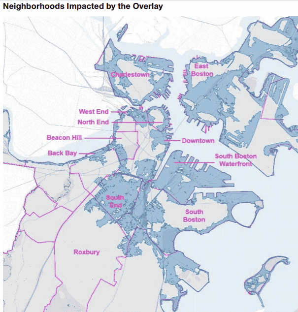
The Boston Planning & Development Agency plans to roll out a new coastal flood zoning overlay that will cover every parcel with a projected 1 percent annual chance of flooding in 2070. Image courtesy of the city of Boston
Boston to Launch New Regs
While design on Clippership Wharf began before the Climate Ready Boston initiative set in motion the city’s preparedness efforts, future projects along Boston’s waterfront like Accordia Partners’ redevelopment of the Bayside Expo Center will have to contend with a new coastal flooding zoning overlay being developed by the BPDA alongside those inland in the South End, Charlestown’s Rutherford Avenue and the Newmarket industrial zone. The overlay will cover every parcel with a projected 1 percent annual chance of flooding in 2070, assuming sea levels rise by 40 inches.
The new regulations won’t be presented to the city Zoning Commission for another six to eight months, but on Sept. 12 city officials published a set of design guidelines for projects in the affected area.
The guidelines offer a menu of options for developers, owners of existing commercial and residential buildings and homeowners, grading the options by cost, ease and speed of implementation. The city has also recently added a coastal flooding overlay to its online zoning viewer to allow property owners to gauge their exposure to coastal flood risk.
The guidelines also encourage owners of existing buildings in at-risk areas to raise the lowest interior floor or relocate its uses entirely to additions on top of the building. However, a city spokesperson confirmed the zoning overlay is not currently expected to add density or height bonuses to accommodate this in specific neighborhoods, but such changes might be made later.
Life Science Under Water?
The threat from flooding also hangs over one of the next big frontiers for life science real estate: The Alewife “Quad.”
Developers are eyeing the industrial area bordered by Fresh Pond Parkway, Concord Avenue and developments along Cambridgepark Drive, inspired by Bulfinch Cos. and The Davis Cos.’ nearby successes.
However, the area faces a flood risk by 2030 in the event of an especially severe rainstorm, and a serious nor’easter or hurricane could overwhelm the Somerville dam that protects the area by 2070. Like Boston, Cambridge has also rolled out an online tool that property owners can use to determine their exposure.
Like Clippership Wharf, the buildings in Bulfinch’s just-completed Cambridge Discovery Park are elevated above the 2070 flood projections and use defenses engineered into their surrounding open space to keep the water at bay. Thanks to skillful landscape architecture, company President Robert Schlager said, those defenses are also amenities where tenants can take a stroll or simply enjoy from their office windows.
“Because of experience [and long-term ownership strategy], we try to predict the future as far ahead as we can,” he said. “In a car, the speedometer goes up to 100 mph, but how often do you go that fast? Not often, but you want to be able to do that if you need to.”
City planners are hoping to put some of the same techniques to work elsewhere, said Cambridge Assistant City Manager for Development Iram Farooq. New citywide resiliency zoning expected next year may require new projects to be elevated above the flood line. A second sidewalk or terrace in front of ground-floor retail uses, set higher up than the main sidewalk, could help preserve street-level vibrance, she said.
Money a Key Obstacle
Climate change resilience features are seen as a valuable addition to projects, said ULI New England Director of Policy and Outreach Manikka Bowman, but not every commercial developer, source of financing or insurance provider sees them as necessary right now.
“Unless you’re talking about more long-term asset holders, the insurance market is responding to the marketplace,” she said. “There are some necessary conversations that need to take place that can get people to think beyond the three-year or the five-year window of bringing a product to market.”
Absent government requirements, cost is the primary obstacle.
“There are clearly tradeoffs – this stuff is expensive,” said Jeff Malloy, who leads the climate change adaptation practice at the Boston-based planning firm BSC Group. “At this point with [many adaptations] it’s a hedge. It’s hard to spend more money if you don’t have to.”
Despite hard financial realities, Farooq said, few developers have pushed back against her staff’s encouragement to design climate change resilience into recent projects, even on expensive asks like raising a building’s ground floor level.

James Sanna
“Partly it’s enlightened self-interest because the impacts are close enough – if you look at 2030 there are impacts,” she said. “Which is not to say developers don’t complain about anything that costs extra, because the bottom line is very important, but it’s been very heartening to see that it hasn’t been a big fight in any of these instances.”
For now, Boston’s new zoning overlay offers a good tool to help waterfront developers work together to build the city’s first line of defense, Clippership Wharf’s Iselin said.
The city is also developing long-term plans for seawalls and other infrastructure that can keep out storm surges starting with a rebuilt Moakley Park in South Boston. Boston Mayor Marty Walsh budgeted $2 million towards design and pre-construction for the project in the city’s fiscal year 2020 budget.
Still, government mandates may be the only way to protect urban areas and knit different municipalities together to close gaps in the region’s defenses, Bowman said.
“When the waters rise, they’re not going to say, ‘This is Quincy, so I’m not going to go there,’” she said.