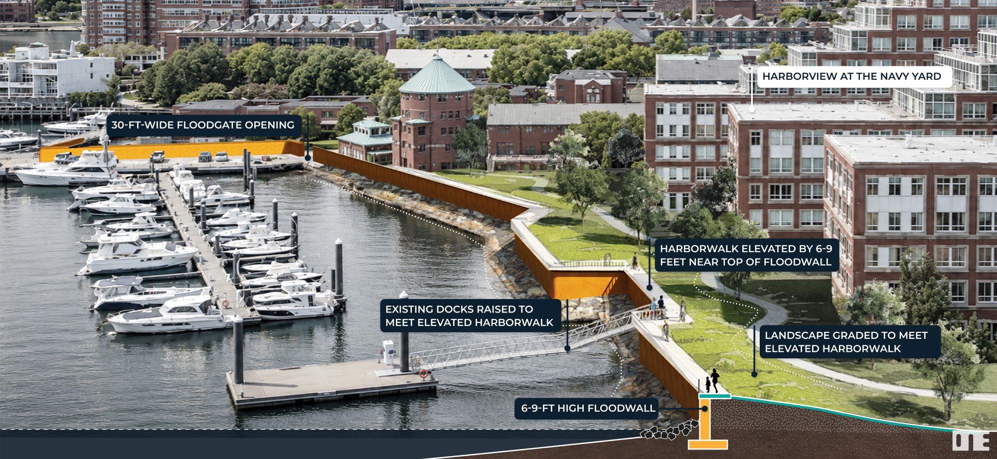
An artist's impression, released by the city of Boston, of conceptual flood defenses in the Charlestown Navy Yard. Image courtesy of the city of Boston
A set of draft recommendations from the federal government leave out major parts of Boston’s economy like the Flynn Marine Industrial Park, the city said Monday.
In a webpage made public before an afternoon press conference, the Wu administration highlighted three areas where the Army Corps of Engineers study of potential Boston Harbor flood defenses, expected to be released Friday, passes on protecting parts of the city.
The Corps’ report is expected to include a “preferred option” where flood defenses in South Boston and the Seaport stop at D Street, Summer Street and the portal to the Ted Williams Tunnel, forcing property owners in the Flynn Marine Park to flood-proof their own properties. The city would prefer a flood wall that follows the current shoreline and ties into smaller-scale flood defenses the city has already set in motion.
Smaller areas left unprotected by the Corps’ “preferred option” include industrial properties between Chelsea Creek and Route 1A north of the Chelsea Street Bridge that largely serve Logan Airport, and luxury condominium developments on Union Wharf, Boroughs Wharf and Battery Wharf, plus a city-owned parking lot on Sargent Wharf that regularly receives “sunny day” flooding.
The report appears to have abandoned an earlier proposal to leave other prominent parts of the waterfront, including the New England Aquarium and Rowes Wharf, outside proposed flood walls.
The expected recommendations reflect engineering decisions, Army Corps of Engineers officials said after Monday’s press conference – floodwaters from a hurricane or a nor’easter blocked from one place must be managed elsewhere in the harbor – but they also are an attempt to manage the flood defenses’ price tag.
Enclosing the Flynn Marine Park in a seawall, for example, would add roughly $1.7 billion to the $10 billion or more the network of levees and seawalls will cost, Army Corps of Engineers project manager Jeffrey Herzog said. Putting a flood barrier between the East Boston industrial properties and Chelsea Creek would cost about $70 million more. Added costs in one area could impact designs in other areas, too.
“Anyone who has fresh catch and seafood, from Colorado to Georgia is likely getting something out of” the Flynn Marine Park, Herzog said. “So, if we do nothing there, then there’s an economic impact. However, does that economic impact outweigh the additional $1.7 billion in cost, and potential environmental impacts?”
The Corps will be looking for information about those tradeoffs in public comments on the draft, Herzog said. The public comment period will run from July 24 through Sept. 18.
‘Doing Nothing Not a Solution’

Boston Mayor Michelle Wu speaks to reporters from a dock at Langone Park in Boston’s North End as she and officials from the Army Corps of Engineers announce the completion of a draft plan for the city’s harbor flood defenses. Photo by James Sanna | Banker & Tradesman Staff
The recommendations previewed by the city Monday appear to embrace building defenses at the water’s edge or in the water, and avoiding any kind of “managed retreat” from encroaching seas, or leaving some property owners to fend for themselves. It’s an approach to dealing with storms and sea level rise championed both by Mayor Michelle Wu, residents’ groups, business groups like the Boston Green Ribbon Commission and property owners like the Wharf District Council.
“Today marks a major milestone in Boston’s fight to protect our city from climate change,” Wu said. The study “will give us the clearest picture we’ve ever had of how rising seas and stronger storms threaten our neighborhoods. And, importantly, the report will also lay out a plan for Boston to become the greener, healthier, more resilient city our residents deserve.”
The city’s 47 miles of vulnerable coastline would see 20 separate flood defense projects built in various stages over two decades or more, officials said Monday, from seawalls downtown to a multi-layered rebuild of South Boston’s Moakley Park, closing off a flood pathway that threatens – alongside Boston’s Fort Point Channel – to swamp parts of the city as far away as the South End. It’s unclear if the Fort Point Channel will be covered by the Corps’ study upstream of the Northern Avenue Bridge.
The Corps’ report is critical to paying for defenses, which have been under discussion in some form or other since at least 2016, after Hurricane Sandy devastated swaths of New York City in 2012. Had it hit Boston, the effect would have been similar, city of Boston Chief Climate Officer Brian Swett said. If Congress also approves, the federal government would pick up the tab for 65 percent of each project identified in the Corps’ Boston flood defenses report.
Those tens of billions of federal dollars would be money well spent, Corps officials argued at Monday’s press conference, given the scale of Boston’s vulnerability in the years ahead and its economic importance.
“Doing nothing is not a viable solution,” Lt. Col. David MacPhail said. “The cost to public safety and economic viability from coastal flooding will be compounded and untenable.”

An artist’s impression, released by the city of Boston, of conceptual flood defenses in East Boston. City officials say while the Army Corps of Engineers study covers flood walls and berms, the city will design ways for the defenses to be integrated into public parks and the Harborwalk. Image courtesy of the city of Boston