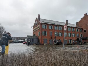
Storm-driven flood waters inundate Boston’s Long Wharf in December 2022. Photo by James Sanna | Banker & Tradesman Staff
Construction of a flood barrier to protect downtown Boston from sea level rise faces major hurdles in designing an effective defense while avoiding structural damage to Long Wharf and the MBTA Blue Line tunnel, according to preliminary findings by consultants.
Consultants hired by the Boston Planning & Development Agency estimate property damages from flooding in the downtown waterfront will rise to $137 million annually beginning in the 2030s. Properties including the Custom House Block office building, Chart House restaurant and MBTA’s Aquarium station have flooded during king tides and coastal storms in recent years.
But all of the potential flood defenses face engineering, logistical and permitting hurdles, Kleinfelder Principal Engineer Andre Martecchini said during a recent public presentation.
“The MBTA Blue Line tunnel is right under the wharf,” Martecchini said. “It’s an older tunnel, so if we think of building structures on top of the wharf, we have to be very cognizant about how we load the tunnels down below.”
The Long Wharf resilience study is taking a look at the city’s options to block a key flood path into the downtown area, including installation of permanent and temporary flood barriers, and elevating existing seawalls and the Boston Harborwalk. Kleinfelder and Stoss Landscape Urbanism are partnering on the study, which is due to release its recommendations this spring.
Permanent new structures would have to be designed to avoid placing additional weight on the 18th-century pier and the harbor floor above the MBTA Blue Line tunnel, Martecchini said. Any new flood barriers would have to be designed to preserve public access, emergency vehicles and deliveries to the summer tourism magnet. And installation of new bulkheads extending into the harbor would face stiff hurdles related to preserving navigational channels.
“We’re going to shy away from brand-new bulkheads as much as possible because of the permitting issues associated with that,” Martecchini said.
One engineering solution to avoid putting stress on the Blue Line tunnel would be excavating the harbor floor and replacing the existing material with lightweight fill, Martecchini said.
A potential location for a passive flood barrier is the north side of the Custom House Block, the current location of the Boston Seaboat marina. The area could be filled to create a living shoreline that dissipates wave action, Martecchini said.
One particularly vulnerable property is the Custom House Block, including the Chart House restaurant and a historic warehouse-turned-office-building, which was acquired by New York-based Capital Properties in 2015 for $34 million.
A 2018 storm flooded the first floor of the building, Martecchini noted. By 2070, based upon the anticipated sea level rise, a king tide storm with moderate waves would nearly reach the second floor.
A representative of Capital Properties declined to comment.
The consultant team expects to release a draft report in May, followed by a public comment period.
Costs of the options have not been determined, but officials said they expect the project would be paid by a mixture of local, state and federal funds.
A separate study by the Wharf District Council, a nonprofit neighborhood group, recommends an $877 million flood barrier including elevation of the Boston Harborwalk to repel flood waters. The initial report by consultants Arup recommended a 7,800-foot-long barrier from Christopher Columbus Park to Congress Street.
The city of Boston and the Army Corps of Engineers also are partnering on a coastal storm risk management study that would enable the city to apply for federal funding.


